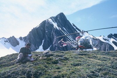
The Canadian Rockies, with their rugged mountain peaks and alpine meadows, are a major tourist attraction. The southern Canadian Rockies, which are designated as a UNESCO World Heritage Site, were the focus of a major Geological Survey of Canada research project during the summers of 1965 and 1966. Called Operation Bow-Athabasca, the goal was to systematically study and map the region’s geology. Its project leader Raymond Price was to go on to become the Survey’s Director General in 1982.
The use of a two-passenger helicopter to deploy ten geologists enabled the study and mapping of this huge area, which totalled about 27,000 square kilometres. This allowed the team to accomplish as much in the two summers’ work as could have been done in two decades using earlier-style packhorses and foot traverses.
Operation Bow-Athabasca produced 39 1:50,000 scale geological maps with cross-sections that explained the nature and evolution of the Canadian Rockies. It also provided insights into the formation of similar mountain belts found elsewhere.
Category: Science Advances
Decade: 1960s
References
Price, R.A., 2000. The Southern Canadian Rockies: Evolution of a Fold and Thrust Belt; GeoCanada 2000, Field Trip Guidebook 13, Canadian Society of Petroleum Geologists; Calgary, Alberta, 244 p.
Gadd, B., 2012. Operation Bow-Athabasca - The Geological Survey of Canada Takes on the Rockies; Canmore Museum and Geoscience Centre, Canmore, Alberta, 72 p. [including CD-based digital versions of the 39 published Bow-Athabasca 1:50 000 scale maps and cross-sections.]
What’s a geologic map? https://www.nature.nps.gov/geology/usgsnps/gmap/gmap1.html


