
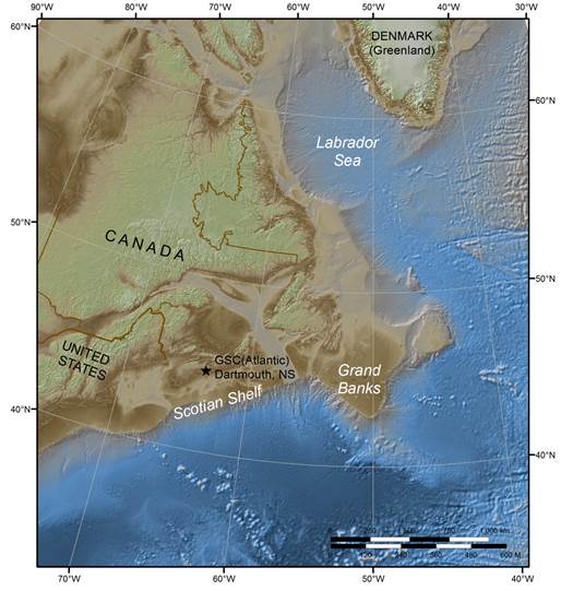
Map 1: Atlantic
Atlantic activity by year:
2004 - present
- Analysis and mapping of previously collected data at the Geological Survey of Canada in Dartmouth, NS
2006
- A multibeam bathymetric survey around the Grand Banks
2007
- Reflection seismic and bathymetric surveys off the Scotian Shelf
2009
- Seismic survey in the Labrador Sea in cooperation with Denmark
- Seismic and multi-beam bathymetry surveys of the Labrador Margin
2012
- Joint Canada –US survey off the Scotian Shelf
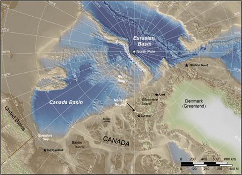
Map 2: Arctic
Arctic Activity by year:
2006
- An on-ice expedition, called LORITA (Lomonosov Ridge Test of Appurtenance), was carried out on Lomonosov Ridge by Canada and Denmark.
2007
- A bathymetry survey was conducted from Canadian Forces Station Alert.
- Canada participated in the Danish survey of the Lomonosov Ridge called LOMROG (Lomonosov Ridge off Greenland), which used the Swedish research vessel Oden to collect bathymetric and seismic data.
- Bathymetric and test seismic surveys of the Canada Basin were conducted from the Canadian Coast Guard icebreaker Louis S. St-Laurent.
2008
- A refraction seismic survey and through-ice bathymetry of the Alpha Ridge, called ARTA (Alpha Ridge Test of Appurtenance), was carried out from an ice-camp at the mouth of Nansen Sound, Ellesmere Island. Read about ARTA.
- Project Cornerstone begins with the goal of developing the equipment and methodology necessary to collect high-resolution, hydrographic-quality, bathymetric data of the Arctic seabed in harsh weather conditions. In this joint project of Canadian Hydrographic Service (part of Fisheries and Oceans Canada), and the Geological Survey of Canada (part of Natural Resources Canada) and the Defence Research and Development Canada, AUVs were used to collect bathymetry data to augment previously collected spot soundings and seismic, gravity and magnetic information. Read the Project Cornerstone newsletters.
- Canada and the US carry out their first joint survey using the CCGS Louis S. St-Laurent and the USCGC Healy to collect bathymetric and seismic data in Canada Basin.
2009
- A Canadian-Danish through-ice sounding program was carried out in the winter of 2009, using helicopters from an ice camp located on the Ward Hunt ice shelf.
- A Canadian-Danish aero-gravity and aero-magnetic program between Ellesmere Island and the North Pole, was flown from Eureka, CFS Alert and Station Nord.
- Canada participates in the joint Danish-Swedish survey LOMROG II (Lomonosov Ridge off Greenland).
- Canada and the US carry out their second joint survey using the CCGS Louis S. St-Laurent and the USCGC Healy to collect bathymetric and seismic data in Canada Basin.
2010
- Bathymetry surveys and gravity readings were conducted from the Borden Island ice camp. After trials off the west coast, the AUVs were deployed for the first time in the Arctic from a remote camp off the Borden Island ice camp and collected bathymetric data.
- Canada and the US carry out their third joint survey using the CCGS Louis S. St-Laurent and the USCGC Healy to collect bathymetric and seismic data in Canada Basin.
2011
- Canada and the US carry out a fourth joint survey using the CCGS Louis S. St-Laurent and the USCGC Healy to collect seismic and bathymetric data, including in Canada Basin. The AUVs were deployed from a vessel for the first time in the Arctic, following testing of the launch procedure in the St. Lawrence River.
2014
- Bathymetric and seismic surveys conducted from the CCGS Louis S. St-Laurent and the CCGS Terry Fox in the Eurasian Basin on the Lomonosov Ridge and areas in the vicinity of the North Pole.
2015
- Bathymetric and seismic surveys conducted from the CCGS Louis S. St-Laurent and the CCGS Terry Fox in the Eurasian Basin on the Lomonosov Ridge and areas in the vicinity of the North Pole.