
Text and photos by Vivien Cumming – @drvivcumming
The river winds its way, cutting the easiest path through a remote landscape that only those brave enough to travel it are lucky to see. Our journey is somehow increasing in length everyday — the shortest path is not always the easiest. Our navigation through the water avoids rocks and shallows and is more haphazard than can accurately be measured on a map. We are reminded by our wise river guides: “Follow the water, and it will show you the way.”
About halfway down the roughly 200-km section of the Coppermine River, the landscape changed dramatically.
Green mountains made up of endless layers of dark lava flows with a gentle, wide river flowing between them gave way to steeper-walled canyons of red sandstone, the overlying rocks in the sequence. Here, the river is much more unforgiving. We tackled our fair share of rapids, ones we knew were ahead and ones that were not expected.
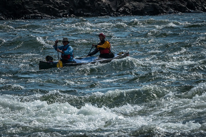
Photo 1 - Tackling rapids in the Coppermine River with fully loaded canoes.
We had already gone through several barrels of food, but the canoes didn’t get much lighter since the barrels were now used for our rock samples — perfect ballast for some expeditions, I’m sure, but not for tackling rapids with four-foot waves that fill your canoe with water!
The rapids along the Coppermine are memorable for their turbulence and their beauty, and have been given apt names: Muskox Rapids, where we saw a large herd of muskoxen grazing their way across the landscape; Sandstone Rapids, surrounded by layered cliffs of red sandstone; and Escape Rapids, where the escape is through a narrow gorge, which made for a spectacular camping spot on the edge of a rocky cliff. A canoe group following us didn’t escape its clutches: the swirling currents swallowed one of their boats, which we were able to help them recover.
The sandstones here are fluvial deposits, deposited by another river more than a billion years ago. There is something wonderful about travelling along a river cutting its way through rocks that are remnants of ancient rivers gone by.
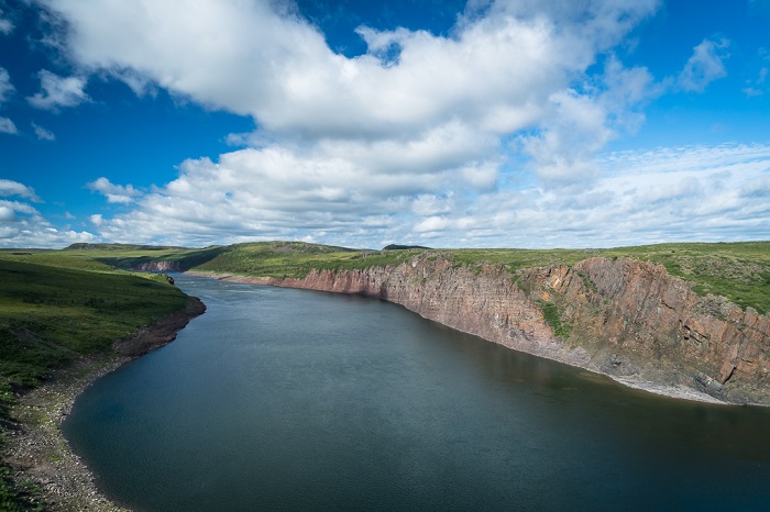
Photo 2 - Sandstone canyons of the Husky Creek Formation, ancient fluvial deposits.
As you examine layers of sedimentary rocks with geologists, their minds are always asking the questions: What kind of environment were these sediments deposited in? When were they laid down? How and under what climatic conditions? What brought these sediments here: a river, an ocean, a glacier? We have seen or could imagine all possibilitiesl on this journey through time.
The structures and minerals in the rocks give clues to how they were deposited. You can even tell the direction an ancient river flowed from the structures formed by the currents and imprinted in the rock. Alessandro Ielpi, a fluvial sedimentologist from Laurentian University, and his student Robbie Meek are the first to meticulously measure these structures in the sandstone so that they can build up a picture of how the area once looked.
Each day, they come back exclaiming about all the new structures they have discovered in the rocks, most of which we can see on river banks today, like ripples and mud cracks that have been preserved to tell the story of the path of a fossilized river.
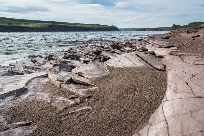
Photo 3 - Modern ripples in sand sitting on top of ancient ripples in sandstone.
An important part of this trip is finding out the exact age of these rocks. We already know they are roughly just over a billion years old, but more precise dating would allow us to pinpoint exactly how the huge volcanic eruptions and other forces affected life and the climate.
Bill Davis of the Geological Survey of Canada has been collecting samples throughout the trip to find samples of zircon, a very hardy mineral that can be used to determine the age of rocks through radioactive elements — isotopes — held within the mineral.
As the river winds its way through spectacular canyons and gorges, we reach yet another set of sedimentary rocks on top of the red fluvial sandstones. They are lightly coloured sandstones and dark shales deposited in a marine environment, suggesting a higher sea level in ancient times. The shales show small black flakes, evidence that more microfossils might be preserved. By comparing the fossils found before and after the volcanic events, we can get an idea of how this huge eruption affected life and consider whether it helped or hindered the diversification of life on this planet.
The fossils we are looking for are broadly named as Acritarchs. The word comes from the ancient Greek words acritos meaning confused and arch meaning old. So as you can surmise, we are looking at some old and confusing rocks! And what is most confusing is that in the field all we can do is sample them — we won’t see the actual fossils themselves until we get back to a lab and use powerful microscopes to examine them.
Early explorers came here in search of the source of copper, travelling up and down the Coppermine River by canoe, sourcing food from the land along the way and wearing animal skins. We come here with our modern canoes, barrels of food and GORE-TEX clothing, examining the same rocks, this time in search of the story of life — but, as a nice link to earlier expeditions, we did also find a small nugget of copper.
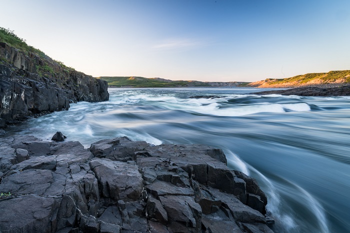
Photo 4: The spectacular Bloody Falls, not suitable for a canoe!
Our last night is spent at Bloody Falls, now called Kugluk, named by the eighteenth-century English explorer Samuel Hearne, the first European to travel across northern Canada to the Arctic Ocean. The name he gave was fitting, since it was here that his Chipewyan Dene guides massacred a group of Inuit in 1771. Today, the scene is a spectacular set of rapids too dangerous for canoes and teeming with Arctic char making their way up river to spawn. For us, it means a long portage, carrying rocks and canoes around this still somewhat terrifying obstacle.
Four golden eagles appear to guide us as we sail our linked canoes down the last section of river, buffeted by favourable southerly winds. Entering Kugluktuk, the Inuit hamlet of 1,500 at the mouth of the Coppermine River on the Arctic Ocean’s coast, we are warmly greeted by children’s smiling faces and many questions about our adventure on this legendary river.
Rob Rainbird, the leader of the expedition, reflects on this amazing journey: “This was a dream come true, to mount a research expedition that accomplished all of its goals at the same time as providing our own low-cost, low-impact transportation, and having maybe just a little bit of fun along the way. Thanks to great weather, an excellent research team and expert guiding, we did it!”
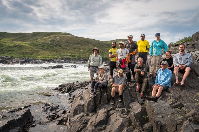
Photo 5: The team at Bloody Falls.