
Defining the outer limits of Canada’s continental shelf means that researchers have to scientifically demonstrate that the extended continental shelf is a natural prolongation of Canada’s land territory. Article 76 of the UN Convention on the Law of the Sea provides a process and criteria for a coastal state to define its outer limits beyond 200 M and gain international recognition for those limits. The continental shelf beyond 200 M is informally called the extended continental shelf (see figure below).
As of 2015, Canada has completed 20 surveys in the Atlantic and Arctic Oceans to map the seabed's topography (shape), and the thickness of deposits (sediment thickness). In addition, Canada has drawn on existing data from various sources.
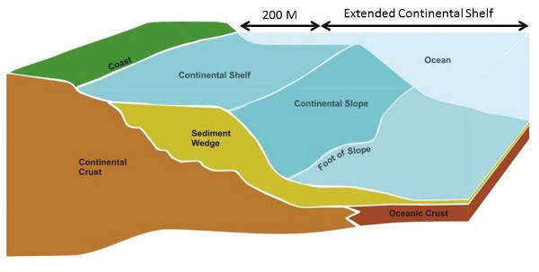
The continental shelf is the natural extension of the continent as it descends to the ocean floor. The extended continental shelf is the area beyond 200 M. Article 76 of UNCLOS provides a process and criteria by which a country can define the outer limits of its continental shelf beyond 200 M and gain international recognition for those limits.
Seismic Surveys
Seismic surveys map the seafloor and measure the thickness of sediment. This method uses sound waves that travel through the sediments and water column. Some of the energy in the sound waves reflects (echoes) off the seafloor and some of the energy penetrates into the earth below the seafloor and reflects off various geologic layers. Geologists interpret these data to determine which reflections represent sediments and which represent bedrock and are able to measure the sediment thickness as a result.
Seismic surveys are done in two ways:
- Sound sources and receivers are towed underwater behind the ship. In the Arctic, they are towed behind an icebreaker and are deep enough to be beneath the ice. Data are recorded almost continuously as the ship advances.
- Researchers work from ice camps in remote areas of the Arctic that are not accessible by icebreakers. Holes are drilled through the ice to place receivers and then depth charges are detonated under the ice, sending seismic waves through the water to gather, measure, and record the data. In this case, data acquired are site specific and not continuous.
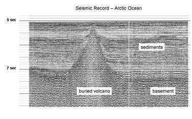
Example of a seismic record from the 2009 joint survey showing a volcano (about 2 km high) buried under sediments.
Bathymetric Surveys
Bathymetric surveys use sonar (sound waves of higher frequency than the seismic waves) to measure the depth of the ocean. From these data, you can create a detailed image of the topography of the seafloor. A device is mounted under a survey vessel that rapidly sends out beams of high frequency sound signals or “pings”. The sonar listens for the echoes of the pings from the seabed and then calculates the water depth based on the time taken for the echoes to return. Multi-beam bathymetry uses hundreds of beams that sweep the seafloor (in an array), creating an even more detailed image.
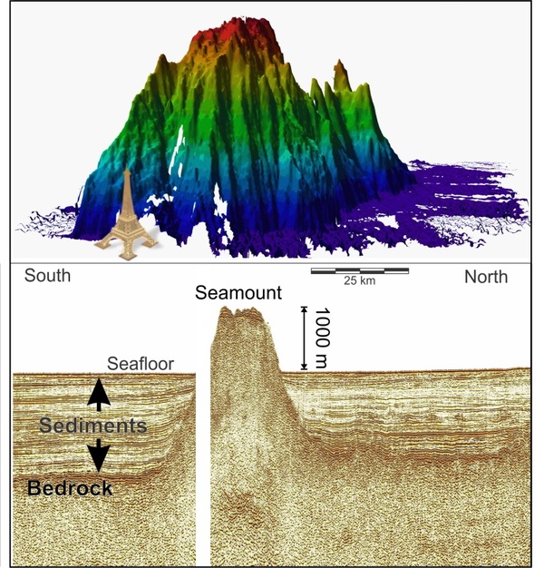
Top: 3D image generated by multibeam bathymetric data of a seamount discovered in the Arctic Ocean during surveying; the Eiffel tower is shown for scale. Below: a seismic profile over the seamount, showing that most of it is buried by sediments, but still over 1000 m of it stands above the adjacent seafloor
Previously Collected Data
Previously collected data are being used, particularly for the Atlantic margins. Unlike the offshore Arctic region of Canada, a significant amount of scientific data on Canada’s Atlantic margins has already been collected over the last five decades. Therefore, some detective work to uncover these data was required prior to designing a research program to determine the extended continental shelf.
Scientists dug into Canada’s archives, and turned to previous collaborators, such as Germany, Denmark, and the US, to compile existing seismic and bathymetric data. After amalgamating existing data, it became clear that the focus of previous data collection had been on or near the continental slope and that large information gaps existed in areas further offshore.
Using the existing information as a guide, researchers determined where additional data were required, as well as the type of data (e.g., bathymetric or seismic) that was needed, to fill in the gaps and be able to define the outer limits of the continental shelf according to article 76 of the United Nations Convention on the Law of the Sea (UNCLOS).
To learn more about how scientific data are used to determine Canada’s extended continental shelf under article 76 of UNCLOS, please visit: http://www.international.gc.ca/media/aff/news-communiques/2013/12/09a_bg2.aspx?lang=eng