
November 2024 | Canadian Food Inspection Agency | by Bruce Craig and Delanie Khan-Dobson
When it comes to pin-pointing sources of food-borne illness, tracking detections of a new invasive plant pest, or studying the spread of an animal disease, geographic data is a powerful tool that helps the Canadian Food Inspection Agency (CFIA) respond effectively to challenges and emergencies.
My name is Bruce Craig, and I am a National Geomatics Specialist at the CFIA. Geomatics is a broad term for the science of gathering, storing, and analyzing geographic or spatial data and information. Geographic Information Systems (GIS) are geomatics tools used to visualize this data in ways that help us better understand problems and provide important clues on how to solve them. By using GIS and geospatial data, the CFIA can rapidly track and monitor threats to complex food safety, plant health and animal health systems. This not only improves the speed of response, but also helps identify patterns that can help improve prevention strategies and support data-driven decision-making.
Before joining the CFIA, I was a Fish and Wildlife Technologist and a Forestry Technologist, where I spent a lot of time in the field and often used GIS for surveys. I became completely captivated by the usefulness – and potential – of these tools. I decided to dive head-first into the field and enrol in a GIS program to learn more about this exciting field.
When I joined the CFIA in 2002, I began working in rabies research, and then worked in plant health starting in 2003. As I learned more about the diverse work of the Agency in food safety, animal health and plant protection, I realized it would be a great place for me to develop and apply my skills in geomatics. GIS applications were first used informally in 2002 by the Plant Health Surveillance Unit for invasive species monitoring, and in animal health for rabies research. Initially, it was just me and two others working with these emerging technologies.
Over the years, there has been a major increase in demand for our work using GIS applications. The CFIA has introduced new services, licensing, and support to comfortably learn and stay up to date with the technology as it adapts. GIS applications at the CFIA have now evolved from basic mapping tools to well-developed platforms that enable complex data collection, spatial analysis, and increased collaboration throughout the Agency.
Geomatics applications at the CFIA
The CFIA’s adoption of GIS technologies has revolutionized how the Agency can better understand and protect Canada’s incredibly diverse landscape. GIS specialists take information from reports and spreadsheets to create accessible maps and databases that provide a much clearer picture of the complex relationships between activities and products.
GIS specialists are often working behind the scenes, but their knowledge and expertise are incredibly helpful in supporting the CFIA’s mandate to proactively address potential risks, monitor disease outbreaks, and safeguard our food.
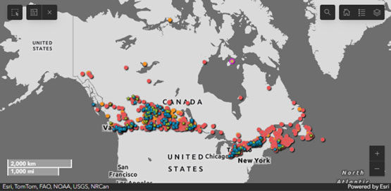
The high pathogenicity avian influenza in wildlife dashboard is a collaboration between the CFIA, Environment and Climate Change Canada (ECCC) and the Canadian Wildlife Health Cooperative (CWHC). The interactive tool allows data to be filtered by criteria.
Though there are just 7 GIS analysts in the Agency, the impact of these experts is clear in the number of geomatic applications that are used. Here are just a few examples:
- Supporting the management of avian influenza in farmed birds with a map of avian influenza primary control zones.
- Providing accurate and open information on detections of avian influenza in wildlife.
- Communicating movement controls to prevent the spread of multinucleate sphere unknown (MSX) in oysters.
- Mapping declared areas for finfish and molluscan diseases across Canada.
- Defining regulated areas for Japanese beetle in British Columbia and regulated areas for Emerald Ash Borer across Canada to help prevent the spread of these damaging pests.
- Providing tools to members of the Canadian Plant Health Information System (CPHIS) to help plant health stakeholders predict, prepare for, and respond to emerging threats.
- Using GIS applications for the real-time reporting and analysis of plant health surveillance activities.
- Collaborating with federal partners to share information on shellfish harvest area closures.
The importance of geomatics
As a science-based organization, the CFIA heavily relies on GIS data for effective decision-making. Maps are like onions – they hold layers of information that can help us to access, understand, and manage data and information from the Earth. GIS applications help to peel away the layers and offer a broad range of advantages like enhanced data visualization, spatial analysis capabilities, and informed decision-making.
Ultimately, GIS helps create models and identify trends so that the CFIA can be more proactive rather than reactive. For example, if an invasive species is drawn to a particular species of plant, this technology can pinpoint where this plant may be located within Canada, and the Agency can use this information to target high risk areas and enhance our response.
A word of advice for future geomatics experts
The most important aspect of my work – and what should drive someone who may be interested in the field of geomatics – is the problem-solving aspect. If you like identifying problems and finding solutions, this is the field for you. Find a training program to learn the fundamentals and immerse yourself in this dynamic and ever-changing field.
Evolving geomatics applications at CFIA have revolutionized how we work at the Agency, and they will continue to do so as demand increases and technologies evolves. I’m excited to help develop and implement new, intuitive tools that help make us more efficient – and hope to welcome a growing number of dedicated GIS specialists to the CFIA.